



The Long-Range Identification and Tracking (LRIT) system is a satellite-based ship monitoring framework mandated by the IMO under SOLAS V/19-1.
It allows Contracting Governments to track ships beyond AIS and radar range for maritime safety, security, and environmental protection.
While shipboard LRIT operations are automatic, a complex international infrastructure manages the collection, processing, and secure distribution of this data.
This article breaks down that system- its components, data centers, and how information flows globally.
⚙️ Main Components of the LRIT System
To grasp how LRIT works, it’s essential to understand the core elements within its architecture:
- Shipborne LRIT Equipment – Usually integrated with the ship’s satellite communication systems (Inmarsat C or equivalent).
- Communication Service Provider (CSP) – Transmits LRIT data from ship to shore via satellite links.
- Application Service Provider (ASP) – Bridges the CSP and the Data Center by formatting and authenticating data.
- LRIT Data Center – Receives and stores positional data, making it available to authorized users.
- Data Distribution Plan (DDP) – Governs how LRIT data is shared with Contracting Governments.
- International Data Exchange (IDE) – Ensures secure, standardized data sharing across global data centers.
These components interact seamlessly to track vessel movements over long distances in compliance with SOLAS Regulation V/19-1.

🌍 Types of LRIT Data Centers Explained
The LRIT Data Center, also referred to as a Vessel Monitoring System (VMS), is where ship data is stored and processed for distribution.
Each ship’s LRIT information is routed to a specific data center based on the Contracting Government’s selection.
🏛️ 1. National LRIT Data Centers
Certain countries operate their own independent LRIT Data Centers to serve their flagged vessels.
These provide direct control over maritime data security and sovereignty.
Examples of countries with National Data Centers:
- 🇺🇸 United States of America
- 🇮🇳 India
- 🇸🇬 Singapore
- 🇳🇬 Nigeria
- 🇵🇭 Philippines
These centers are fully responsible for processing, managing, and distributing LRIT data of their registered ships.

🌐 2. Regional LRIT Data Centers
A Regional LRIT Data Center serves multiple countries within a defined geographic area.
It is established through collaboration among states within a specific region to optimize infrastructure and cost.
Example:
Several West African states may share a regional center to collectively manage their LRIT responsibilities.
🤝 3. Cooperative LRIT Data Centers
These are similar to regional centers but are not limited by geography.
Member countries agree to co-manage an LRIT data center regardless of location.
Example:
The European Union LRIT Cooperative Data Center (EU LRIT CDC) serves multiple European nations under a unified data management agreement.
🌐 4. International LRIT Data Center
If a country does not participate in any of the above models, its ships report to an International LRIT Data Center, typically managed by an organization designated by the IMO.
This ensures universal coverage and data consistency for all vessels under SOLAS compliance.

🔁 How LRIT Data Flows from Ship to Shore
The flow of LRIT data begins at the ship and ends at authorized government users through a chain of secure infrastructure.
Here’s how it works:
- The ship’s LRIT equipment transmits encrypted position reports via satellite to a Communication Service Provider (CSP).
- The CSP forwards the data to an Application Service Provider (ASP), which reformats it according to LRIT standards.
- The ASP submits the processed data to the ship’s assigned LRIT Data Center.
- The Data Center stores the information and enables access for authorized users like Flag States, Coastal States, Port States, and SAR authorities.
- All cross-border or inter-governmental requests are routed via the International LRIT Data Exchange (IDE).
This process ensures real-time, secure, and standardized monitoring of vessels worldwide.
🌐 The Role of the International Data Exchange (IDE)
The International LRIT Data Exchange (IDE) is the central hub that connects all LRIT Data Centers worldwide.
It ensures that the tracking system remains:
✅ Standardized
Ships use different equipment and formats.
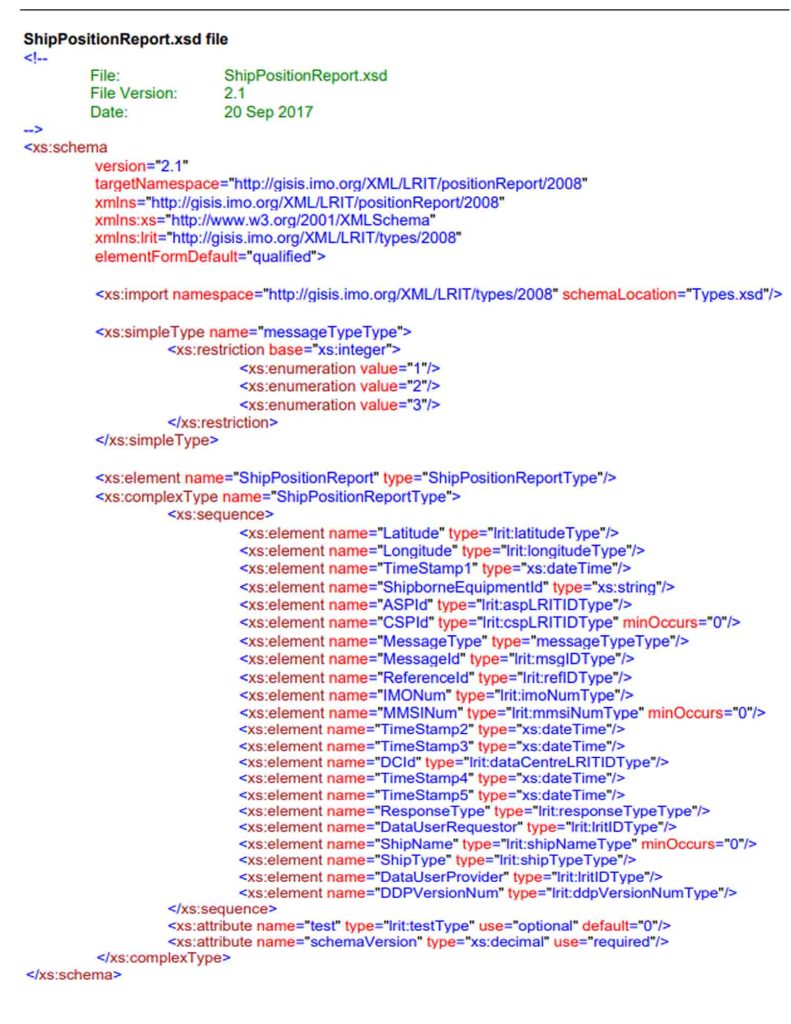
The IDE converts position reports into a uniform XML Schema recognized across the LRIT network.
✅ Efficient
Without the IDE, each government would need to query multiple data centers.
With the IDE, there’s a single point of access for cross-border LRIT data requests.
✅ Globally Integrated
Whether a vessel is under a National or Cooperative Data Center, the IDE enables seamless global vessel tracking, supporting IMO’s goal of universal maritime surveillance.
🗂️ Did you know? The ship’s position report is formatted in a standardized XML file that includes the ship’s MMSI, IMO number, latitude, longitude, and timestamp.
📤 The LRIT Data Distribution Plan (DDP)
The Data Distribution Plan (DDP) governs how LRIT information is shared among authorized users. It defines:
- Who can access the data (e.g., Flag State, SAR authorities)
- What type of data they can receive (e.g., ship position, identity)
- How the data is routed and secured within the LRIT system
The DDP connects directly with the Data Centers and the IDE, ensuring the flow of data is compliant, confidential, and operationally useful.
🆚 LRIT vs AIS: Architectural Differences
While AIS and LRIT both track ships, their architecture and purpose are fundamentally different:
| Feature | LRIT | AIS |
|---|---|---|
| Range | Satellite (Global) | VHF (40–60 NM) |
| Data Visibility | Restricted to authorized users | Public and open |
| Transmission Frequency | Periodic (per DDP rules) | Continuous |
| Purpose | Security, search and rescue, compliance | Collision avoidance, situational awareness |
| Infrastructure | Multi-layered (CSP, ASP, Data Centers, IDE) | Direct ship-to-ship and ship-to-shore |
👉 LRIT’s architecture is more complex but ensures secure, regulated long-range vessel tracking, ideal for governmental and SAR use.
📚 Conclusion: LRIT’s Global Role in Maritime Security
Understanding the LRIT system’s architecture helps seafarers and maritime authorities appreciate its importance in global vessel identification, coastal state control, and search and rescue operations.
From onboard transmitters to international data exchanges, the LRIT system supports maritime safety through a regulated, encrypted, and standardized data ecosystem.
⚓ Whether you’re a cadet or a senior officer, knowing how LRIT functions behind the scenes strengthens your maritime situational awareness.
❓FAQ: LRIT System Architecture
What is the main function of the LRIT Data Center?
It receives, stores, and distributes LRIT position reports of ships flying a Contracting Government’s flag.
Why is the International Data Exchange important?
The IDE ensures secure and standardized data sharing between LRIT Data Centers globally.
How is LRIT different from AIS?
LRIT uses satellite transmission and is restricted to authorized users, while AIS is public and VHF-based.
Who can access LRIT data?
Authorized entities like Flag States, Coastal States, Port States, and SAR authorities as defined in the DDP.
📢 Call to Action
Want to learn more about vessel tracking systems like LRIT and AIS?
📘 Check out our related articles on Shipboard Navigation Systems and GMDSS Components to expand your maritime knowledge.
May the winds be in your favor.
Leave a Reply