


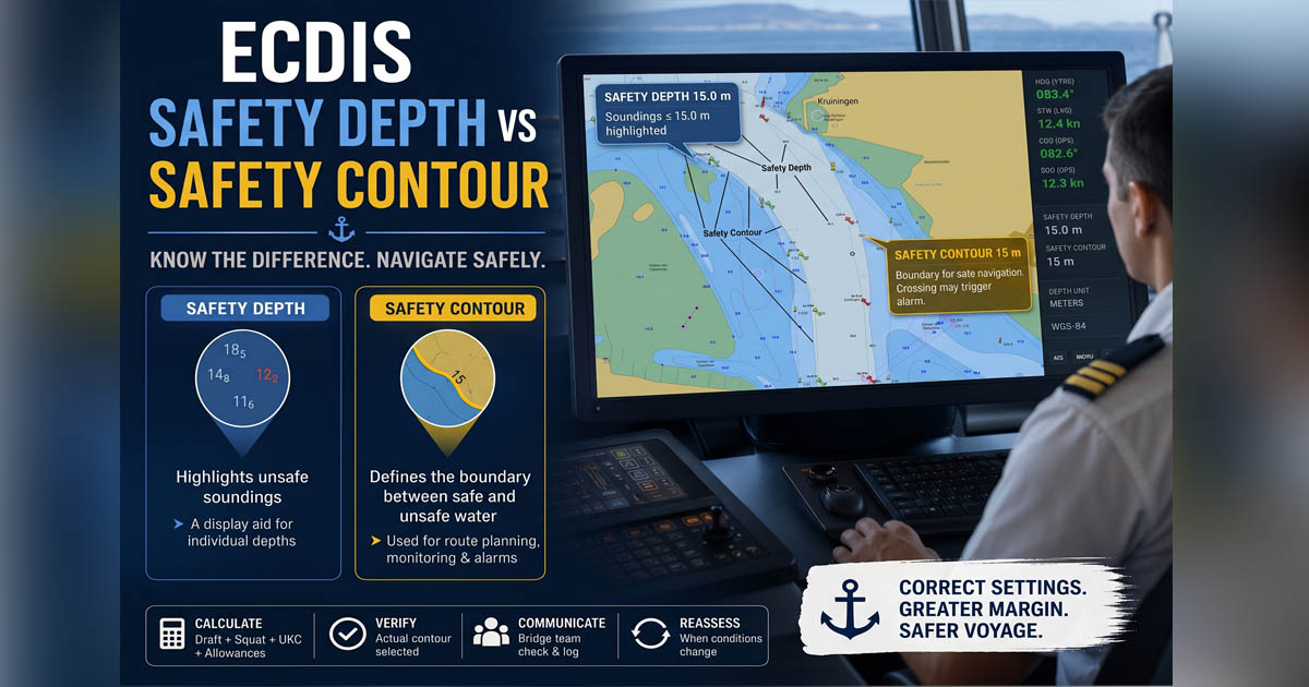
Safety Depth and Safety Contour are not the same setting. Safety Depth makes potentially unsafe individual charted soundings more conspicuous. Safety Contour establishes the boundary between navigable and unsafe water for the vessel and is used by ECDIS for safety-related route planning and monitoring.
Confusing the two can lead to incorrect assumptions about what the ECDIS is actually protecting.
A laden 19,000 GT bulk carrier, drawing 10.6 m, works through confined waters with the ECDIS safety contour set to 10 m. The visual alarm triggers but goes unnoticed, and the disconnected audible alarm stays silent as the ship enters unsafe water, grounding at 12 knots. The incident report cites inadequate type-specific ECDIS training. (Source: Westpandi)
⚓ Safety Depth vs Safety Contour: The Key Difference
| Setting | Main Function | What It Affects |
| Safety Depth | Highlights potentially unsafe soundings | Individual depth figures |
| Safety Contour | Defines the safety boundary for navigation | Depth contour, depth shading, route monitoring |
Safety Depth: A Sounding Filter
Safety Depth is primarily a display aid.
When spot soundings are enabled, soundings equal to or less than the selected Safety Depth are emphasized so that potentially critical depths are easier for the OOW to identify. It does not create a new contour or define the vessel’s safe water boundary.
For example, if the Safety Depth is set to 15.0 m, charted soundings of 15.0 m or less are displayed more prominently than deeper soundings, depending on the ECDIS presentation.
This helps the bridge team quickly identify critical soundings during route planning and monitoring.
Safety Contour: The Navigation Safety Boundary
The Safety Contour has a different purpose.
The IMO Resolution MSC.232(82) requires ECDIS to allow the mariner to select a Safety Contour from the depth contours available in the system’s chart data. The selected contour is emphasized on the display and is used as an important safety parameter during route planning and route monitoring.
If the exact Safety Contour requested by the navigator is not available in the ENC, the system should select the next deeper available contour and inform the mariner.
This is why the OOW must never assume that the value entered is necessarily the contour being displayed.
📌 Important: Do not rely only on the number entered into the menu. Confirm the actual Safety Contour selected and portrayed on the chart.
📐 How to Calculate the Required Safe Depth
Before configuring either parameter, determine the vessel’s required minimum navigable depth.
A practical planning model is:
Required Safe Depth = Maximum Draft + Squat + Required UKC + Applicable Allowances
Applicable allowances may include factors required by the vessel’s SMS, such as:
- Hog or sag correction
- Fresh water allowance
- Heel or list
- Wave response
- Expected changes in squat
- Hydrographic uncertainty
- Company or Master-required safety margins
The exact calculation must follow the vessel’s approved UKC policy, passage planning procedures, and SMS.
Example Calculation
| Input | Example |
| Maximum operational draft | 12.80 m |
| Expected squat | +0.90 m |
| Required UKC | +1.30 m |
| Additional approved allowance | 0.00 m |
| Required Safe Depth | 15.00 m |
In this example, the navigator should ensure that the selected Safety Contour provides a boundary consistent with the vessel’s required safe depth and the company’s operational procedures.
⚠️ Do not use the shallowest depth on the route minus an arbitrary buffer to determine the Safety Contour. The starting point should be the vessel’s own depth requirement, not simply the depth available in the fairway.
🌊 What About Tide?
Charted depths are normally referred to chart datum. Predicted or observed tidal height may therefore be considered during passage planning when determining the available water depth.
However, tide should not be treated as permanent margin.
For example, a vessel may plan a restricted-water transit around a specific tidal window. If the vessel is delayed, the available tidal height may change significantly. The bridge team should reassess the under-keel clearance and relevant safety parameters when the original tidal assumptions are no longer valid.
Best practice: Record the tidal assumptions used in the passage plan and reassess them when the transit time, draft, speed, or operating conditions change.
📊 CATZOC and Hydrographic Uncertainty
CATZOC information provides an indication of the confidence associated with hydrographic data in an ENC. It is valuable during passage planning, especially when operating close to depth limits or outside well-surveyed channels.
However, CATZOC should not automatically be treated as a fixed numerical allowance added to every Safety Depth or Safety Contour calculation.
Instead, the navigator should consider:
- The quality and age of hydrographic information
- The vessel’s proximity to limiting depths
- The requirements of the vessel’s SMS
- Company UKC policy
- The consequences of a charted depth error in the planned area
IHO standards require chart data quality information to be available to the mariner through the ENC and ECDIS environment.
💡 Practical rule: The closer the vessel operates to its limiting depth, the more important hydrographic uncertainty becomes in the overall risk assessment.
⚙️ How to Set Safety Depth and Safety Contour
A disciplined OOW configuration process can follow these steps:
1. Determine the vessel’s maximum operational draft
Use the relevant draft for the planned voyage and include any applicable trim, hog, or sag considerations required by company procedures.
2. Calculate expected squat
Squat depends on several factors, including speed, hull form, water depth, and channel confinement.
Do not treat squat as a universal fixed value. Use approved vessel-specific information, company guidance, or an appropriate calculation method.
Reducing speed in restricted water may significantly reduce squat and increase the available under-keel margin.
3. Apply the required UKC and allowances
Follow the vessel’s SMS and the approved passage plan.
The result should establish the vessel’s required minimum depth for the specific operation.
4. Set the Safety Contour
Select a Safety Contour that is appropriate for the calculated depth requirement.
If the exact value is unavailable in the ENC, ECDIS presentation rules require selection of the next deeper available contour and notification to the mariner.
5. Verify the actual displayed contour
This is critical.
Check the chart display and confirm:
- Which contour the ECDIS selected
- Where the safety boundary lies
- Whether the route approaches or crosses that boundary
- Whether the selected contour remains appropriate in the next ENC
The available contours can change between ENC cells. A Safety Contour suitable in one chart area may therefore require verification when entering another chart.
6. Set the Safety Depth
Set the Safety Depth so that soundings relevant to the vessel’s depth limitations are clearly emphasized.
Remember that Safety Depth is an aid for identifying critical spot soundings. It does not replace the Safety Contour or the route safety check.
🚨 Route Planning and Monitoring: What the OOW Must Check
The IMO ECDIS Performance Standards include an alarm for crossing the Safety Contour and an indication for route planning across the Safety Contour.
However, an ECDIS alarm is not a substitute for proper passage planning.
The bridge team must still:
- Conduct the route check
- Review charted depths and dangers
- Check the selected Safety Contour
- Assess available UKC
- Review CATZOC and chart quality
- Consider tides and water-level information
- Recalculate squat when speed or conditions change
- Monitor the vessel’s position and progress continuously
⚠️ Never assume that one ECDIS setting protects against every grounding hazard.
👥 Bridge Team Best Practice
Safety settings should be treated as voyage-critical parameters.
A practical bridge team procedure is:
- Calculate the required depth using approved vessel procedures.
- Propose the Safety Depth and Safety Contour.
- Verify the selected contour on the chart display.
- Check the route against the selected safety boundary.
- Record the relevant assumptions where required by the SMS.
- Communicate the settings during watch handover.
- Reassess the settings whenever conditions change.
Review the settings when:
- Draft changes after cargo operations
- The vessel enters restricted water
- Planned speed changes significantly
- Squat conditions change
- A tidal transit is delayed
- The vessel enters a new ENC area
- The passage plan is amended
❓ Frequently Asked Questions
What is the difference between Safety Depth and Safety Contour?
Safety Depth emphasizes individual spot soundings that are equal to or shallower than the selected value. Safety Contour defines the charted depth boundary used to distinguish safer water from shallower water for the vessel’s selected safety setting.
Should Safety Depth and Safety Contour always have the same value?
Not necessarily. They perform different functions and should be set according to the vessel’s navigational requirements, SMS, and the purpose of each setting.
What happens if the requested Safety Contour does not exist in the ENC?
The ECDIS should select the next deeper available contour and inform the mariner. This is why the actual displayed contour must always be verified.
Does crossing the Safety Contour generate an alarm?
The IMO Resolution MSC.232(82) ECDIS Performance Standards list crossing the Safety Contour as an alarm function. The exact presentation and operational behavior should also be understood through the vessel’s specific ECDIS model and approved operating procedures.
How often should ECDIS safety settings be reviewed?
Review them whenever a change could affect the vessel’s depth requirement or available water, including changes in draft, speed, squat conditions, tidal assumptions, navigational area, or passage plan.
⚓ Final Takeaway
Safety Depth and Safety Contour are two different tools with two different jobs.
Safety Depth helps the OOW identify critical soundings.
Safety Contour establishes the charted safety boundary used for route planning and monitoring.
The safest workflow is simple:
Calculate the vessel’s required depth → Apply approved UKC and allowances → Set the Safety Contour → Verify the contour actually selected → Set Safety Depth to emphasize critical soundings → Reassess whenever conditions change.
Join our email list to stay updated!
May the winds be in your favor.
Leave a Reply