


Global Navigation Satellite System (GNSS) spoofing has become an operational reality.
Operating in choke points like the Baltic, Black Sea, Red Sea, Eastern Mediterranean, Arabian Gulf, and Strait of Hormuz exposes bridge teams to corrupted satellite data.
Unlike jamming, which causes overt signal loss, spoofing feeds deceptive coordinates and timing to receivers.
When ECDIS displays a ‘Valid Fix’ (green indicator) but the position is inland, shows impossible speeds, or creates circular tracks, the OOW must act immediately.
This guide provides a bridge protocol to detect false satellite fixes, isolate compromised equipment, and navigate safely under SOLAS Chapter V.
Quick Summary: The OOW Action Protocol
When GNSS anomalies occur, execute the Detect -> Verify -> Isolate -> Navigate -> Monitor -> Record protocol:
- Detect: Spot warning signs like position jumps, circular tracks, UTC shifts, and speed over ground (SOG) errors.
- Verify: Cross-check displayed positions against radar ranges, visual bearings, depth contours, and dead reckoning.
- Isolate: Disconnect corrupted GNSS feeds on ECDIS, switch position input to Dead Reckoning (DR) mode, and set radar to sea-stabilized.
- Navigate: Maintain passage using radar Parallel Indexing (PI), optical bearings, clearing ranges, and echo sounder depths.
- Monitor: Disengage Track Control autopilot modes, switch to heading control or hand steering, and double bridge lookouts.
- Record & Report: Log the event in the Deck Logbook, preserve Voyage Data Recorder (VDR) data, and alert coastal authorities or UKMTO.
GNSS Spoofing vs. Jamming: The Bridge Threat
Recognizing the technical difference between jamming and spoofing is critical for early threat identification:
- GNSS Jamming: High-power radio frequency noise overpowers authentic satellite signals. Receivers lose constellation lock (GPS, GLONASS, Galileo, BeiDou), triggering bridge alarms like “GNSS Signal Lost.”
- GNSS Spoofing: A transmitter broadcasts deceptive radio signals mimicking authentic satellite data. Receivers lock onto the false signal, calculating incorrect positions and UTC timestamps while reporting a “Valid Fix” status with normal Dilution of Precision (HDOP/PDOP) values.
Because spoofing can produce believable but false navigation information, it may be harder to recognize than a straightforward loss of GNSS signal.
| Feature | GNSS Jamming | GNSS Spoofing |
| ECDIS Fix Status | Lost / Invalid (Alarms trigger) | Valid / Normal (Green fix indicator remains) |
| Displayed Track | DR activates or freezes | Circular loops, inland positions, or offset jumps |
| Receiver Alarms | “Signal Lost”, “Position Lost” | Often silent; occasional RAIM alerts |
| Speed Over Ground (SOG) | Zero or unavailable | Unrealistic values (e.g., 0.0 or 100+ knots) |
| UTC Bridge Clocks | Retains last known time | Jumps by hours, days, or years |
| Primary Danger | Loss of automated position | False confidence causing automated steering errors |
Primary Bridge Indicators: Detecting Spoofing Early
Spoofing creates distinct discrepancies across integrated bridge systems (IBS):
1. ECDIS Track Anomalies
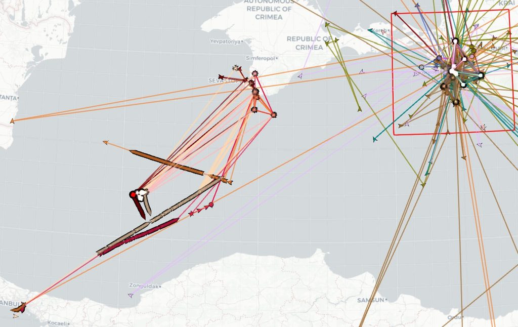
- Circular Track Loops: Vessels show looping circular tracks on ECDIS while holding a steady gyro heading.
- Geographic Impossibility: Plotted positions jump onto land, airports, or miles off track without course changes.
- Speed/Course Divergence: SOG and COG diverge sharply from Speed Through Water (STW) and Gyro Heading.
2. Time and Sensor Inconsistencies
- UTC Clock Drifts: Master clocks, GMDSS consoles, and satellite terminals display incorrect dates or erratic offsets.
- SNR Spikes: Diagnostics show all channels with identical, unusually high signal levels from a terrestrial source.
- RAIM Alerts: Receiver Autonomous Integrity Monitoring (RAIM) displays integrity warnings or fails residual checks.
3. Equipment Cascades
- Radar Overlay Shift: Raw radar coastline returns fail to align with charted vector features on ECDIS.
- AIS Target Errors: Surrounding vessels appear clustered at a single point, or your own AIS broadcasts false coordinates.
- GMDSS Position Errors: Digital Selective Calling (DSC) units display corrupted coordinates, threatening distress alerting accuracy.
The 6-Step OOW Bridge Response Procedure
When suspecting GNSS spoofing, execute this structured protocol under the vessel’s SMS.
Step 1: Detect the Anomaly
Maintain active vigilance. Never treat ECDIS as infallible. In high-risk waters, inspect GNSS receiver diagnostics regularly for constellation tracking and signal health.
Step 2: Verify the Position Independently
Verify true position using physical methods:
- Radar Cross-Check: Compare radar ranges and bearings to charted headlands, islands, or fixed platforms.
- Visual Fixes: Take optical bearings of conspicuous landmarks, lighthouses, or leading lines, plotting fixes manually.
- Bathymetric Cross-Check: Compare echo sounder depths against charted contours, accounting for draft and tide.
- Compass Comparison: Check gyro repeaters against the standard magnetic compass to confirm heading integrity.
Step 3: Isolate Compromised Systems
Prevent corrupt GNSS data from driving automated operations:
- Switch ECDIS Inputs: Switch to Secondary GNSS. If both feeds fail, switch ECDIS position input to Dead Reckoning (DR) or Estimated Position (EP) mode.
- Reconfigure Radar Stabilization: Switch radar stabilization to Sea-Stabilized using Speed Through Water (Doppler log) and Gyro heading, keeping ARPA collision vectors valid under COLREGs Rule 7 and Rule 8.
- Notify the Master: Inform the Master immediately that active spoofing is occurring and manual controls are active.
Step 4: Navigate Using Terrestrial and Sensor Methods
Transition to conventional navigation methods:
- Radar Parallel Indexing (PI): Run parallel index lines on raw radar against conspicuous targets to keep the vessel within cross-track limits (XTD).
- Manual Position Plotting: Plot fixes frequently (every 6 to 12 minutes in coastal waters; every 15 to 30 minutes in open waters) using radar ranges, visual bearings, or celestial sights.
- Clearing Lines: Set up clearing bearings and safety depth contours to avoid navigational hazards.
Step 5: Monitor and Control the Vessel
Adjust bridge workload and steering control:
- Disengage Autopilot Track Control (TCS): Disconnect TCS immediately. Revert to Heading Control Mode or hand steering to prevent violent rudder orders.
- Increase Bridge Manning: Post additional lookouts and call a second officer to divide ARPA monitoring and manual fixing.
- Filter AIS Information: Treat AIS data cautiously. Rely on raw radar echoes and visual lookouts for collision assessment.
Step 6: Record and Report
Maintain complete documentation:
- Logbook Entries: Record UTC detection time, last verified position, spoofed coordinates, and manual actions in the Official Deck Logbook.
- Preserve VDR Data: Execute manual backup on the Voyage Data Recorder (VDR) to lock sensor logs, audio, and radar imagery.
- Report to Authorities: Send reports or VHF security messages to local MRCC, coastal VTS, and regional bodies (UKMTO, IMB, MARAD).
Downstream Bridge Cascades: What Else Fails During Spoofing?
Primary GNSS receivers feed multiple bridge systems. When GNSS is spoofed, downstream equipment degrades:
- Autopilot Track Control (TCS): False cross-track errors order hard rudder, steering into danger.
- AIS Transponders: Broadcasts fake coordinates, misleading traffic and VTS.
- GMDSS Distress Alerting: Automated DSC distress alerts broadcast false coordinates, misdirecting rescue units.
- Radar Ground Vectors: ARPA true motion vectors become invalid if ground stabilization uses satellite feeds.
- Dynamic Positioning (DP): DP vessels experience false position loss alarms or unwanted thrusters.
Regulatory Framework: SOLAS Chapter V and SMS Compliance
Navigating without reliable GNSS is a mandatory competency under international conventions:
- SOLAS V/19: Requires applicable ships to carry navigation equipment and a means of establishing and updating the ship’s position throughout the intended voyage.
- SOLAS V/27: Require nautical charts and nautical publications necessary for the intended voyage to be adequate and up to date.
- SOLAS V/34: Requires the voyage to be planned before proceeding to sea and places responsibility on the Master for ensuring safe navigation.
- IMO Res. MSC.232(82): Provides for manual position fixing and dead-reckoning capabilities in ECDIS, supporting navigation when continuous positioning information is unreliable.
- STCW Section A-VIII/2: Establishes watchkeeping principles requiring effective monitoring of the ship’s position, course and speed and the proper use of available navigational information.
During Port State Control (PSC) and vetting audits (SIRE 2.0, RightShip), inspectors regularly check if bridge teams can engage ECDIS manual DR mode and execute parallel indexing.
Common OOW Mistakes During Spoofing Incidents
Avoid these common errors:
- Trusting Green ECDIS Status: Assuming positions are valid because status indicators remain green.
- Leaving Autopilot in Track Mode: Allowing automated track control to order hard rudder from false cross-track errors.
- Using Ground-Stabilized Radar: Failing to switch to sea stabilization, corrupting ARPA collision vectors.
- Over-Relying on AIS: Trusting AIS target vectors when surrounding traffic is also spoofed.
- Delaying Manual Navigation: Waiting for restricted waters before starting dead reckoning and parallel indexing.
Frequently Asked Questions (FAQ)
What is the fastest way to confirm GNSS spoofing on ECDIS?
Enable raw radar overlay on ECDIS. If radar coastline returns offset from charted vector objects while gyro heading aligns with radar heading markers, GNSS input is compromised.
Can GNSS spoofing affect magnetic compasses or gyro compasses?
No. Magnetic compasses and mechanical gyro compasses operate independently of satellite signals and remain reliable. However, satellite compasses (GNSS attitude sensors) will be corrupted and should be isolated.
Should the OOW switch off the AIS transponder during spoofing?
No, unless authorized by the Master and permitted by regulations. Switching off AIS removes your presence for nearby vessels. The proper action is logging the anomaly and informing VTS.
How does sea-stabilized radar differ from ground-stabilized radar during spoofing?
Sea-stabilized radar calculates target motion through water using Gyro heading and Doppler log speed. Ground-stabilized radar uses GNSS over the seabed. During spoofing, ground vectors fail, while sea-stabilized radar remains reliable for collision avoidance.
Conclusion
GNSS spoofing tests the core seamanship and navigation competencies of the modern deck officer.
Electronic navigation aids provide convenience, but they do not relieve the OOW of the obligation to maintain situational awareness through multi-sensor verification.
By swiftly detecting position anomalies, isolating corrupted inputs, switching ECDIS to dead reckoning, and executing radar parallel indexing, bridge teams can navigate safely through contested waters.
May the winds be in your favor.
Leave a Reply