


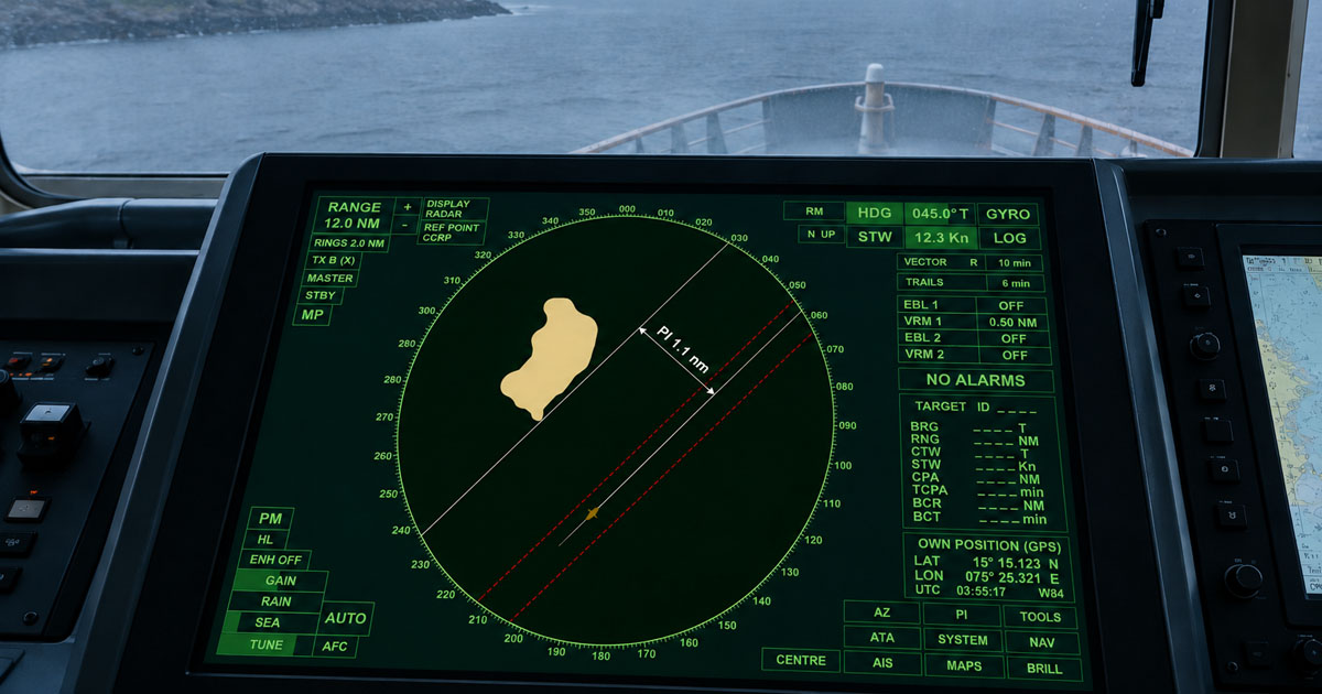
Fog reduces visibility to 200 metres at 0200H, and the channel ahead narrows to a quarter of a mile. Visual navigation is no longer reliable.
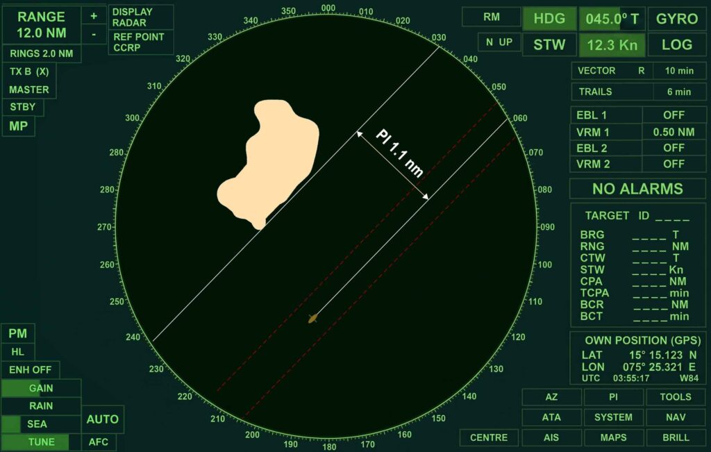
Radar parallel indexing, or PI, provides a continuous reference for monitoring a vessel’s position relative to the planned track and nearby hazards. It helps the OOW quickly determine whether the vessel is maintaining the intended passing distance or drifting toward danger.
PI does not replace position fixing or other navigation methods. It is a practical radar monitoring technique that supports safe navigation in confined waters, restricted visibility, and blind pilotage.
⚓ When and Why to Use Parallel Indexing
Parallel indexing is a radar navigation technique used to monitor whether a vessel is maintaining the required distance from a fixed charted feature or hazard.
It supports safe navigation when visual references are limited or unavailable. Typical situations include:
- 🌫️ Restricted visibility and fog
- 🌊 Narrow channels and rivers
- ⚓ Port approaches
- 🗺️ Blind pilotage
- 🌙 Night navigation with limited visual references
- 🧭 Monitoring cross-track deviation near charted hazards
Radar carriage requirements are addressed under SOLAS Chapter V, Regulation 19, while competence in the use of radar and ARPA forms part of applicable STCW Code Section A-I/12 and certification requirements. Under COLREG Rule 5, vessels must maintain a proper lookout by sight, hearing, and all available means appropriate to the circumstances.
Parallel indexing can support that wider navigational assessment by helping the bridge team monitor the vessel’s position relative to the planned track and nearby hazards.
🚢 Shipboard Example
A laden bulk carrier is navigating a narrow river channel at 8 knots. A shoal lies close to the northern side of the channel, while heavy rain has obscured visual navigation marks.
The OOW establishes a PI line using a suitable fixed charted feature and sets the required passing distance. As the vessel proceeds, the relationship between the radar echo and PI line provides an immediate indication of whether the vessel is maintaining the intended lateral clearance.
This allows the bridge team to monitor the vessel’s relationship to the intended track continuously between scheduled position fixes.
📐 How to Establish a Radar Parallel Index Line
A reliable PI setup depends on three things:
- Selecting a suitable radar target
- Determining the correct offset
- Setting the PI line parallel to the intended track
Selecting Suitable PI Objects
The best PI targets are fixed, charted, distinctive, and capable of producing a consistent radar echo.
Suitable targets may include:
- Breakwater heads
- Headlands and prominent points of land
- Isolated rocks or islets
- Jetties and harbour structures
- Other permanent charted structures with identifiable radar returns
Avoid relying primarily on:
- Floating buoys
- Small or weak radar targets
- Indistinct shoreline echoes
- Targets likely to merge with clutter
- Objects affected by construction or temporary changes
| Radar Target | PI Suitability | Main Consideration |
| Breakwater head | Excellent | Confirm the correct charted extremity |
| Isolated rock or islet | Excellent | Verify chart position and chart datum |
| Jetty or prominent structure | Very good | Ensure the radar echo is identifiable |
| Shoreline feature | Moderate | May merge with clutter |
| Buoy | Limited | May be off station or displaced |
💡 Good practice: Select PI objects during passage planning whenever practicable. Record the target, intended passing distance, and relevant wheel-over or monitoring information in the navigation plan or associated planning documentation.
📏 Calculating the PI Offset
The PI offset is the perpendicular distance between the planned track and the selected radar reference that corresponds to the required passing distance or desired lateral separation.
For example, if the passage plan requires the vessel to pass a breakwater head at a minimum distance of 0.15 NM, the PI reference can be set so that maintaining the planned radar relationship with that target confirms the intended passing distance.
Remember:
1 nautical mile = 1,852 metres = 6,076.12 feet
Therefore:
- 0.1 NM = 185.2 meters = 607.6 feet
- 0.15 NM = 277.8 meters = 911.4 feet
- 0.2 NM = 370.4 meters = 1,215.2 feet
The offset must be based on the intended ground track or planned track, not simply the vessel’s heading. Wind, tidal stream, current, and leeway can cause a difference between the heading steered and the actual track made good.
Using PI as a Safety Boundary
Where a hazard exists on one side of the route, a PI line can help monitor the vessel’s clearance from that hazard.
In wider waters or critical channels, bridge teams may use more than one PI reference to improve situational awareness. Each line should have a clear purpose and be understood by the OOW.
Avoid cluttering the radar display with unnecessary lines. Too many references can reduce clarity during a high-workload navigation situation.
📍 Parallel Indexing Is Not a Position Fix
A PI line should not be treated as a position line or as a substitute for a conventional radar fix.
Its primary purpose is to monitor the vessel’s relationship to a planned track, selected radar target, or predefined safety boundary. A vessel may maintain the expected PI relationship while other navigational errors remain undetected.
For this reason, PI should be used together with appropriate position fixing and cross-checking using ECDIS, radar ranges and bearings, GNSS, depth information, visual observations, and other available navigation equipment.
🧭 Parallel Indexing in Relative and True Motion
Parallel indexing can be used in both relative motion and true motion, depending on the radar presentation and the equipment’s available functions.
Relative Motion
In relative motion, own ship normally remains fixed on the display while fixed objects move relative to the vessel.
The navigator monitors the target echo in relation to the PI line. A change from the expected relationship can indicate that the vessel is not maintaining the planned cross-track position.
Relative motion is useful because own ship remains in a consistent position on the display.
True Motion
In true motion, stationary charted objects remain relatively stationary while own ship moves across the radar display.
Many navigators find a north-up presentation useful because it can provide a display orientation similar to the chart or ECDIS presentation.
⚠️ Important: Parallel indexing should be established and interpreted according to the radar manufacturer’s operating principles and the vessel’s approved bridge procedures.
🔄 Using Parallel Indexing During Turns
PI requires additional care during wheel-over and course alterations because the vessel is no longer following the original track.
A Practical Sequence
- Identify the wheel-over position using the passage plan and appropriate navigational references.
- Consider the vessel’s manoeuvring characteristics, including advance and transfer where relevant.
- Prepare the PI reference for the next leg before commencing the turn, when workload permits.
- Monitor the turn using appropriate ranges, bearings, radar information, ECDIS, and other available navigation data.
- Transfer attention to the new PI reference once the vessel is established on the next planned track.
🚢 Shipboard Example
A product tanker is scheduled to make a 40-degree starboard alteration in a river bend. Before reaching the wheel-over position, the bridge team prepares the PI reference associated with the next leg.
During the turn, the OOW monitors the vessel’s movement using multiple sources of information. Once the vessel settles onto the new track, the next PI line becomes the primary cross-track monitoring reference.
⚠️ Do not continue interpreting the old PI line as if the vessel were still on the previous track. After a significant course alteration, the bridge team should prepare and verify the PI reference for the next leg.
⚠️ Common Parallel Indexing Mistakes
Several errors can make an apparently correct PI setup unreliable.
1. Using an Unstable Target
A buoy may move off station. An indistinct shoreline may merge with clutter. Select a target with a reliable and identifiable radar echo.
2. Calculating the Offset from the Wrong Track
The PI line must correspond to the planned track being monitored. A vessel’s heading is not necessarily the same as its track over the ground.
3. Forgetting to Update PI After a Course Change
A PI line established for the previous leg may no longer provide useful cross-track information. Prepare and verify the next reference.
4. Over-Reliance on a Single PI Line
Parallel indexing is only one navigation tool. Cross-check with:
- ECDIS or paper chart
- Radar ranges and bearings
- GNSS position
- Depth sounder
- Visual observations when available
- AIS information, used appropriately
- Other approved bridge navigation equipment
5. Failing to Consider Radar Errors and Limitations
Sea clutter, rain clutter, target aspect, radar tuning, incorrect range scale, heading errors, sensor inaccuracies, and target identification errors can affect the reliability of the information displayed.
Always verify that the radar is properly adjusted and that the selected echo is the intended charted object.
❓ Frequently Asked Questions About Radar Parallel Indexing
Can I use a buoy as a PI object?
A buoy can be used as a secondary reference when appropriate, but a fixed and charted object is generally more reliable because floating aids may be off station or displaced.
What radar range scale is best for PI?
Use a scale that provides sufficient detail while keeping the relevant PI target and surrounding navigational situation visible. Reassess the PI setup when changing range scale or display configuration.
Can PI replace position fixing?
No. Parallel indexing is primarily a continuous monitoring technique. It should supplement, not replace, proper position fixing and the use of all available navigational information.
Should PI be included in passage planning?
Yes. Where PI will be used as part of the bridge team’s navigation strategy, relevant targets, offsets, and monitoring arrangements should be considered during passage planning and bridge team briefing.
⚓ Conclusion: Make Parallel Indexing Part of Active Radar Navigation
Radar parallel indexing is one of the most practical techniques for monitoring cross-track position during restricted visibility and confined-water navigation.
The key is to use PI as part of an integrated navigation system, not as a standalone solution. Combine it with ECDIS, position fixing, radar observations, depth monitoring, visual information, and effective bridge team communication.
Subscribe to our newsletter!
May the winds be in your favor.
Leave a Reply